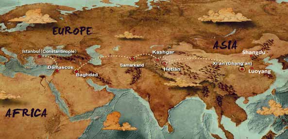
In 1877, the german geographer Ferdinand Von Richthofen (1833-1905) first transported silk from China to Rome and called the road the “Silk Road”. Since then, the “Silk Road” concept has been widely used in various fields of economic and cultural exchanges between the East and the West and has been recorded in many ancient books and documents and spread to the present day. In the first volume of his book, entitled “China: Ergebnisse eigener Reisen un darauf gegründeter Studien” (China: Results of my own travels and studies based on them), published in 1877, Von Richthofen first explicitly put forward the concept of “Seidenstrassen” (“Silk Road”). Richthofen’s silk road concept was based on classical Greek and Roman writers such as Claudius Ptolemaeus and Marinus. Classical writers transliterated the Chinese character for silk as Ser and called China Seres. Richthofen created Sererstrasse by combining the plural of Ser, Serer, with the German word for road, Strasse, and Seidenstrasse in its modern German interpretation. So when Richthofen first called the Silk Road Sererstrasse, it meant “the road to the silk land.” Marinus records that in the second century, a Phoenician merchant named Maes Titianus and his men set out from the crossing of the Euphrates River to reach Sera, the capital of silk, through a
relay station called the Stone Tower (tashkurgan). As for Sera, Richthofen inferred that it was Chang’an in China but should actually be Luoyang, the capital of the Eastern Han Dynasty. Richthofen was keenly aware that the road used by Phoenician traders was probably not the only or even the most important route of silk trafficking in the Eastern and Western worlds. Thus, in his conception, “Silk Road” should be plural “Sererstrassen” or “Seidenstrassen”. However, according to the narrative of “China”, Richthofen’s discussion focused on transportation routes in inland Asia, and the origin and destination of the Silk Road seem to follow the account of Marinus.
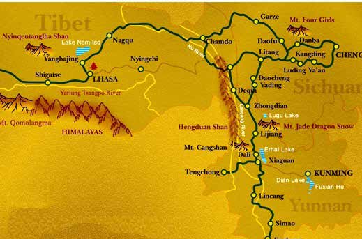
The Silk Road is an important road for exchanges between the East and the West. In particular, it is an important road for political, economic, trade, religious, and cultural exchanges between China and the West. It is also one of the most famous trade routes connecting China and the rest of the world. The Silk Road is generally divided into the overland Silk Road and the maritime Silk Road. The overland Silk Road was also divided into the southern, middle, and northern routes. The southern route was a tea trade route from Tibet on the Qinghai-Tibet Plateau to Yunnan and Hubei, also called the Southern Silk Road or the “Ancient Tea Horse Road”. The middle
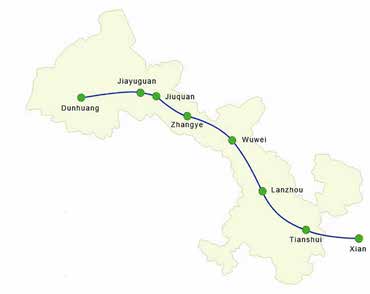
route, also known as the Gobi Silk Road, starts from Chang’an, passes Dunhuang along the Hexi Corridor, and extends westward to Rome. The northern route is the Grassland Silk Road.
The Origin of the Grassland Silk Road
The Grassland Silk Road is the oldest trade road among Mongolian steppe roads. After establishing the Mongol Empire, a grassland trade road centered on the Karakorum was formed. During the Yuan Dynasty, the Grassland Silk Road was an important link between the Gobi Silk Road and the Maritime Silk Road. Since the beginning of the Qing Dynasty, as the Mongolian merchants entered the region to do business, grassland trade routes were formed in all directions.
The full name of the Grassland Silk Road is “The Silk Road connecting Eurasia”, which covers an area of about 50 degrees north latitude. It takes the Mongolian plateau of Hiramulun as its origin, crosses the Xing’an Mountains, and follows the North Yinshan Road westward across the Juyanhai and Tianshan Mountains
to the Black Sea which is one of the earliest roads across the steppes of northern Europe and Asia. In his great work “History”, Herodotus described the extent of the road, the territory it passed through, and the economic and trade conditions along the way. This is the earliest written record of the Grassland Silk Road. According to his records and other archaeological findings, the Grassland Silk Road was the earliest trade road in the Silk Road. From the traces left in the tombs of Xiongnu during the Warring States Period in Hangjin Banner and Tumed Banner of Inner Mongolia, during the Spring and Autumn Period and the Warring States Period, Chinese silk goods were transported to the North by this trade road, from here to the West.
Historically, due to political reasons, the routes and regions of the Grassland Silk Road also changed and migrated with the rise and fall of various ethnic groups. During the Han and Tang dynasties, the road was mainly controlled by the Xiongnu and Turks. During Emperor Wu of the Han Dynasty, the four counties of Hexi were established and the Silk Road of Tarim Basin in Hexi Corridor was officially opened.
After the Xiongnu withdrew from the Hexi Corridor, they continued to operate the silk trade in the central plains. At the same time, they created a new Mobei Shanyuting, along Hangai Mountain in the west, through Hovd Basin, through Altai Mountain, along the Ulungur River in the southwest to Tacheng and then straight to the Taras River region. During the Sui and Tang dynasties, the grassland road continued to extend and develop, and commercial trade became more prosperous and flourishing. Yusuf Hass Hajifu (c. 1010 ~ 1092), a famous Uyghur poet, thinker and political activist, said in his book “The Wisdom of Happiness”: “They have been trading from east to west and have brought you the goods you need. To make the Chinese merchants cut down the flag of the caravanserai, where will the millions of treasures come from?” (Zhang, 1995: 30).
Historically, due to political reasons, the routes and regions of the Grassland Silk Road also changed and migrated with the rise and fall of various ethnic groups.
The “Anshi Rebellion” in the 14th year of Tang Tianbao (755) left Hexi empty of arms. Tubo nobles took the opportunity to invade and occupy most of Hexi Longyou, controlling the Silk Road, the traditional trunk line of transportation between east and west, cutting off the central plains from the Western regions. To maintain the political and economic connection between the central plains and the western regions, the Tang Dynasty had to take the route of the Uighur Road, which is historically known as the “Hui-Hui Road”.
The “Uighur Road” referred to here is centered on Karabalsagun, where Uighur Khar Balgas was located, mainly divided into the southern and western sections. The southern section started from Chang ‘an, passing
Puguan, Taiyuan, Zhenwu (northwest of present-day Inner Mongolia Horinger), Zhongshouxiangcheng City (about the vicinity of present-day Jagger Banner Temple in Inner Mongolia), crossed Yinshan Mountain, and passed present-day Uniwusu to the Wula Sea area to the Road of Karabalsagun, an ancient Uighur village. It is generally believed that the western section traveled northwest along the northern ridge of Hangai Mountain from the Uighur Khar Balgas, crossed the Altai Mountains, followed the southeast of the Junggar Basin, and then turned and went west along the northern ridge of Tianshan Mountain to reach Beiting. According to the Mongolian chronicle, there were two routes from Uliasutai to Xinjiang, Hami and Zhenxi (now Balikun). The route to Zhenxi diverges from the route to Hami at Boleho on the north bank of Uliasutai, and slant to the southwest, passing through the Altai Mountains, Khuzhetu, Bornuru, Almokga, Kulingai Huduk, Dharanzolet, Tamuchendaba Pass, Garshwin, etc. And south into Xinjiang to reach Zhenxi (Yao, 1907: 37). Of course, the names of the places may have changed due to the different times, but at that time, it is estimated that the route from Karabalahasun to Beiting was via this route, instead of going farther to Kebudo or Hami. As you can see, the Uighur Road connects important towns and other commercial roads on the steppe.
After the Mongol Empire was established, it conquered the Eurasian continent and connected the east-west passage. The Northern Steppe Road became an important link connecting the two continents, and several important trade roads were built and formed. In the Yuan Dynasty, with the formation of a unified country of various ethnic groups with vast territory, a network of commercial roads connected in all directions. Generally speaking, the Mongolian area has three horizontal and nine vertical trade roads.
In the “Three Crosses” from Chang’an, South Road crosses the Altai Mountains to the Western regions via
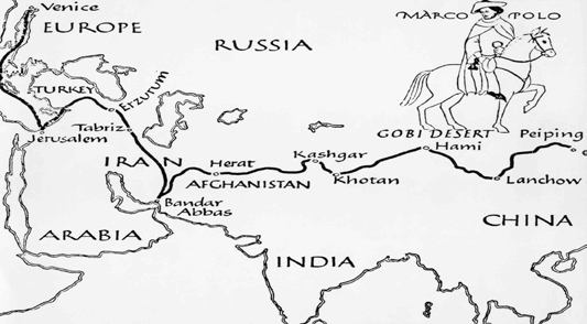
Horinger and Uliasutai. This is the “Uighur Road” mentioned above. In the Yuan Dynasty, it was called “Mu Lin Dao”. Some famous figures mainly traveled Uighur Road through Uighur Road, such as Taoist spiritual master Qiu Chuji, Yeru Chucai, and Changde. The middle line starts from Dadu and Shangdu and reaches the Western regions via Kharahorin, which can be said to be the route taken by Marco Polo. The northern route is from eastern Inner Mongolia to the western regions via Lake Baikal and the upper reaches of the Yenisei River through forests. This is a silk road formed by the peoples of the northern grassland and the so-called “golden Road” of the northern route. The “three horizontal lines” can also be summarized: the north line is the forest road, the middle line is the grassland road, and the south line is the Gobi road. The most important trade routes in the “nine longitudinal”
(1) The trade route from Hailar to Russia via Manchuria; (2) The trade road from Doron to Kuron through Jingpeng; (3) Zhangku Avenue; and (4) The commercial road from Guihua city to Kulun.
These trade routes brought an endless supply of silk, tea, agricultural products, and daily handicrafts to the north, while “mountains” of woolen fabrics and all kinds of precious furs came from the south. This south to north and west to east of the grassland road are silk roads and fur roads. Therefore, the Grassland Silk Road has many names, such as “Fur Road”, “Gold Road”, “Tea Road”, “Camel Road”, “Nalin Road”, “Tieli Road”, and “Mulin road”.
Famous Roads on the Grassland Silk Road
There were many famous roads along the Grassland Silk Road, which also formed famous trade roads. Its formation was connected either with the messengers, monks, and merchants who traveled through it or with the commodities that were trafficked through it.
There were already several roads leading from the west to the east through Mongolia, and John John of Plano Carpini, advised by the King of Bothnia, chose to go to Mongolia through Poland and Kyivan Rus’.
“Poland-Tartar Road” is the famous traveler Giovanni da Pian del Carpine’s (John of Plano Carpini) road from Poland to Tartar Mongolia through Kyivan Rus’ (Роусь), which is called “Po-Tartar Road” for short. This is also how John of Plano Carpini traveled to Mongolia and back, so it can also be called Carpini’s road. There were already several roads leading from the west to the east through Mongolia, and John John of Plano Carpini, advised by the King of Bothnia, chose to go to Mongolia through Poland and Kyivan Rus’. According to the History of Mongolia, which he wrote after his mission to Mongolia, we can get a rough outline of the road.
Poland - Kyivan Rus’
. At that time, there were more frequent contacts between the upper echelons of Poland and Kyivan Rus’, and there were many towns and cities on the roads between the two countries. Passports were issued to incoming and outgoing emissaries, and places were notified of food and informed about the provision of food. So, John of Plano Carpini had a relatively smooth ride.
Kiev - Kaniv.
Kiev was the capital of Kyivan Rus’ at that time, and Kaniv was a town under the direct rule of the Mongols. In the middle of the road, there was a dangerous road near Kyivan Rus’. With the help of the officials, Carpini changed horses and reached the Mongolian territory safely.
Kaniv - Kuoliancha Station.
From Kaniv, Carpini passed through another town and arrived at the first Tatar camp, which was a checkpoint on the Mongolian border, as corresponding to the border post at Kuoliancha.
Kuoliancha Station - Badu Ordo.
Carpini left Kuoliancha and travelled day and night, but he reached Badu Ordo in eight days.
Badu Ordo - Wulerti.
He left the Badu Station and crossed the desert, past the Kangli camp, across the Musuman country, into the Territory of the Black Khitans, and then arrived at the city built by the Tartars.
Wulerti - Guiyou Station.
He went through Walta to Ordo, the first Ordo of Guiyou Khan. He went through the land of the Naiman people and entered Mongolia, arriving at Jin Ordo, the residence of Guiyou. John of Plano Carpini returned from Guiyou station - Badu station - Kuoliancha station - Kiev, following the same way back. This basic information about the Polish- Tartary Road can be obtained from his records:
Firstly, he set out from Kiev on February 3, 1246, and arrived at Guiyou Station on July 22. A total of 169 days. He returned on November 13 departure on winter roads. From here, we can see that the road is about three months ‘ride away.
Secondly, his journeys were all winter journeys, so that from his records we can learn the basics of winter travel. “All the winter we were on the road, sleeping on the snow in the desert, except when we could dig out with our feet. On treeless open plains, we often wake up to find our bodies completely covered in windswept snow.” (Dawson, 1983: 68Dawson, E. (1983). Chinese Envoy to Mongolia (translated by Lu Pu, Zhou Liangxiao zhu). Beijing: China Social Sciences Press. Komroff, M. (Ed.). (2002). The travels of Marco Polo (The Venetian). NY: W. W. Norton & Company. Yao, M. H. (1907). Mongolian Annals. Zhang Zhiyao. (1994). Grassland Silk Road and Central Asian Civilization. Xinjiang: Fine Arts Photography Publishing House.).
Thirdly, at that time, there were two ways to travel, by horseback and by carriage. When riding on horseback,
local and Mongolian horses are generally replaced. “If we ride our horses into a Tatar area, they will all die because there was deep snow, our horses don’t dig grass out from under the snow to eat like the Tartars’ horses do, and we can’t find any other feed to feed the horses, because the Tartars had no straw, hay or fodder.” (Dawson, 1983: 51Dawson, E. (1983). Chinese Envoy to Mongolia (translated by Lu Pu, Zhou Liangxiao zhu). Beijing: China Social Sciences Press. Komroff, M. (Ed.). (2002). The travels of Marco Polo (The Venetian). NY: W. W. Norton & Company. Yao, M. H. (1907). Mongolian Annals. Zhang Zhiyao. (1994). Grassland Silk Road and Central Asian Civilization. Xinjiang: Fine Arts Photography Publishing House.).
Fourthly, emissaries, merchants and other travellers must obtain passports and be escorted as they pass through different parts of the country.
Fifthly, there were dangerous places on the road, such as the attack of the Woorus on passers-by.
Sixthly, he deliberately recorded Mongolian officials at all levels extorting gifts. It was actually a Mongolian means of exchange. It was the same with emissaries and other travellers, depending on the size and value of your gifts. For merchants and business travelers, even more gifts were taken.
Seventhly, his records also reported that the articles owned by the Mongol emperor at that time included not only oriental silk goods but also western jewelry, which indicated that the Karakorum and other towns in the hinterland of Mongolia had become the trade center of the East and the West.
Eighthly, he provides much information about business people. He mentioned many merchants: “Some from Frativia,
others from Poland and Austria, Michler from Genoa from Constantinople, Bartholomew and Manuel from Venice, James of Arkle, Revilius, Nikolay, Pisani, etc.” (Dawson, 1983: 72Dawson, E. (1983). Chinese Envoy to Mongolia (translated by Lu Pu, Zhou Liangxiao zhu). Beijing: China Social Sciences Press. Komroff, M. (Ed.). (2002). The travels of Marco Polo (The Venetian). NY: W. W. Norton & Company. Yao, M. H. (1907). Mongolian Annals. Zhang Zhiyao. (1994). Grassland Silk Road and Central Asian Civilization. Xinjiang: Fine Arts Photography Publishing House.). This shows that many Western merchants came to Mongolia through Russia for commercial trade, and there were also a lot of emissaries and officials with a huge caravan or a lot of followers. Therefore, western travelers at that time not only undertook political, cultural and religious missions but also undertook the mission of material and cultural exchange.
The road is basically divided into five sections, starting in neighboring countries and ending in the Mongol Empire; In the middle through the Mongolian occupation area, direct rule area and nomadic area. It can be seen that the Mongol Empire was directly connected with the western countries through its ruling region.
“Taoist spiritual master’s Road” is Chang Chun Taoist spiritual master westbound itinerary. In spring 1221, Qiuchuji, Chang Chun Taoist spiritual master, was ordered to travel west. He set out from Yanjing, crossed Yehuling mountain in the north, followed the Tieligan Station Road,
Chaghatai Houwang Fiefdom Post Road, and the Persian Road. Through hardships and dangers, he interviewed Genghis Khan on the Great Snow Mountain (now the Hindu Kush Mountain in Afghanistan) in April 1222. He returned to the east in 1223, along the Cantian Khan Road, Jienalin road, via Yijinai road, Tiande, Dongsheng, Datong Road, Xuande House, Juyongguan to Dadu. This is a relatively convenient grassland road formed earlier, and it is also one of the many commercial roads formed later on the Mongolian grassland. We call it “Changchun Taoist spiritual master’s Road” or “Taoist spiritual master’s Road” for short.
The first volume of The Travels of Marco Polo is titled “Account of Regions Visited or Heard of On the Journey from the Lesser Armenia to the Court of the Great Khan at Shangtu” (Komroff, 2002: xxxiii), where he mainly recorded the situation of the countries and regions he passed along the way. Starting from Lesser Armenia, he passed through twelve countries including Greater Armenia, Georgia, Iraq, Persia, Qiran, Shacha, Tanggute, and Siliang, recording fortyone regions or towns along the way to the Mongol Empire’s Kharakhorin, Shangdu and finally to the city of Khanbari City (Dadu). During his stay in China, he traveled to Dadu, Taiyuan, Xi‘an, Chengdu, Xizang, Yunnan and other regions. He returned from the Maritime Silk Road and recorded the local conditions and customs of the seven big countries and forty-one regions or towns he passed through on his return. Therefore Marco Polo was the only traveler who traveled the entire Gobi Silk Road, Grassland Silk Road and maritime Silk Road. The road he traveled when he came to China was an important one in the steppe Silk Road connecting east and West. We call it the “Marco Polo Trail”, the “Marco Trail” for short.
Herodotus mentioned a Scythian people who migrated to the far east after fighting against the Scythian royal family in his masterpiece History, called the Sairen in Chinese
historical records. They lived in the Altai Mountains, a region famous for its gold production, which led the ancient Greeks to mythically refer to the local Altai tribes as the “gryphon guardians of gold” (Zhang, 1994: 74).
In Mongolian, gold is called “Alita” or “Alata”, and the place where there is gold is called “Alatatai”. The so-called Altai Mountain means “mountain of gold” in Mongolian. The Altai region was an important gateway of the grassland Silk Road in ancient times. The main commodity going west through the ancient Altai road is gold. Scythians were engaged in gold trading on this ancient road. Therefore, this section of the grassland Silk Road is also called the “Gold Road”. There are three grassland commercial roads connecting the golden Road: One is from the Guihua city, passing through the areas of Hasatu, Laobiao Temple and Santang Lake to Balikun, and finally to the southern road of the Altai Commercial Road. The second one is from Ulyasutai through Balikun and finally arrives at the middle commercial road of Altai steppe. The third one is the northern steppe trade route from Hovd, which connects to the Altai East Road through Dalai Lake. Therefore, Altai Golden Road is a mysterious road that integrates grassland road, gobi road, waterway and forest road.
The Tea Road is another new international trade road emerging in Eurasia after the decline of the world-famous Silk Road. As a trade road, although it was opened more than 1,000 years later than the Silk Road, in terms of its economic significance and huge cargo of goods, the Silk Road cannot be compared with it.
China is the country of origin of tea. As early as the 6th century, tea became an export product. By the 17th century, China’s brick tea cultivated a stable and large consumer group in Russia and Europe. The brick and black teas imported to Russia came from southern China and were run by businessmen from Shanxi, a non-tea-producing province. Shanxi merchants, commonly known as “Jin merchants”,
bought tea in the Jiangnan tea area. The tea business expanded beyond its borders, and the tea road was extended. At first, Jin merchants mainly bought tea from Wuyi Mountain in Fujian province and processed it locally into tea bricks. Later, the tea was transported from Hunan and Hubei by water to Hankou and then transported to Xiangfan. After that, the tea was landed in boats and transported by vehicles carried by livestock. The tea was transported by Tanghe river and Sheqi in Henan and then crossed the Yellow River from Luoyang. Through Jincheng, Changzhi, Taiyuan, Tatong to Zhangjiakou, the “East Exit” on the Great Wall, or from Shahukou in northern Shanxi, the “Western Exit” of the Great Wall into Guihua City (present-day Hohhot) in Inner Mongolia, then the camel caravan of Jin merchants from the brigade to Mongolia crossed the vast steppes and deserts and traveled more than a thousand kilometers, finally arriving at the Russian-Chinese border crossing at Chakotou for trading. Russian merchants then trafficked to Siberian Irkutsk, Urals, Tyumen and other areas, leading to St.
Petersburg, Moscow and London. This is the basic overview of the Tea Road.
The total length of the Tea Road is about 5,150 kilometers, including about 4,500 kilometers in China from Wuyi Mountain in Fujian province to Kiakhtu, a trading city on the China-Russia border. Guihua City is the starting point of the famous tea road in the east. It is a famous shopping mall and a unique city of Ten Thousand Camels. Its counterpart is the Siberian city of Irkutsk, which sits on the shores of Lake Baikal. It was a gathering place for Russian merchants who specialized in trade with China.
From 1692, when Peter the Great sent the first caravan to Beijing, to 1905, when the Trans-Siberian Railway opened, the commercial road flourished for more than 200 years. Finally, with the decline of Jin merchants, it was gradually abandoned.
The tea road in the East started from the provinces south of the Yangtze River where tea was produced, and its western terminus is the historic city of St. Petersburg in Europe. The grassland trade road from the Guihua
city to Kiakhtu is the most important section of the tea road. Therefore, the tea road can be understood as the extension of the grassland trade road to the east, west, north, and south.
It seems that world history experts have identified this trade road. In July 2005, China’s State Administration of Cultural Heritage announced that the Silk Road would be declared a World cultural heritage site, including the Grassland Silk Road.
In 1989, 1990 and 1992, UNESCO sent three delegations to study the “Overland Silk Road”, “Maritime Silk Road”, and “Grassland Silk Road”, among which Zhangku Avenue is a section of the grassland Silk Road. It seems that world history experts have identified this trade road. In July 2005, China’s State Administration of Cultural Heritage announced that the Silk Road would be declared a World cultural heritage site, including the Grassland Silk Road. Zhang- Ku Trade Road is the continuation of the ancient Silk Road; an ancient trade road revived in Eurasia after the decline of the grassland Silk Road.
Zhang-Ku Avenue is a trade route from Zhangjiakou to Kulun (now Ulan Bator), a city in the hinterland of Mongolian grassland. A large number of historical documents prove that Zhangku Commercial Road is not a commercial road built for the need of establishing a city, but a long history of the continuous evolution of the commercial road, only because the city was established in Kulun in the Kangxi period, Zhangku commercial Road has the name. According to He
Qiutao of the Qing Dynasty, “In the year of Kangxi, the first exchange market was set up in Kulun”. Zhang-Ku Commercial Road should have existed since the Kang- Xi period. Later, Zhangku Avenue shows the expansion and smooth road with huge freight volume.
Historically, there were three roads from Zhangjiakou to Kulun: One was the middle road, starting from Zhangjiakou, landing at Hannuoba, going through Zhangbei (Xinghe), Xianghuangqi, Saihan (Pang River, East and West Sunite banner), Erlian, Zamunwud, Zhalin to Ulan Bator, and then extending to Kiaktu and Moscow in Russia. This is the main road, and most caravans use it.
The second is the East Road, which starts from Zhangjiakou and climbs Chongli Fifty Family Dam. After arriving at the dam, take zhangbeidahulun, Guyuan niuhulun, Yanghulun Nine-Link City and Taipusi Banner, cross Hunshandak desert, cross Huitengliang and Huiteng River, go deep into Backgrass Beizi Temple (Ximeng) or run to Erlian to return to the middle road, or continue to transit north through east and west Wuzhumuqin, to Qiaoba mountain and Ahai banner in the Khan Department of Chechnya, it can also go deep into Russia’s Chita . There were relatively few caravans taking this road.
The third is the northwest Road, starting from Zhangjiakou, boarding Shenweitai dam, Zhangbei, Mantou Ying, Santaiba, Daqinggou, Shangdu, Fengzhen, to Guihua City (today’s Hohhot) area or west to Xinjiang, or north to Ulyasutai, Kebuduo, can also turn from this road to Kulun. There were also many caravans along this road, but most just carried their goods to the city.
Zhang-Ku Avenue covers 12 leagues of Inner Mongolia and Outer Mongolia, more than 150 banners and some areas related to Mongolia include Dorenol, Xilingol, Hulunbuir, Ulanqab, Chahar and Zhaowuda, Guihua, Baotou, YiKeZhao, Alxa, Egina and outer Mongolia Chechen Khan of Khalkha, Tuxietuhan,
Kulun, Ulyasutai, Tangnuwuliang sea, Hovd and northern Xinjiang and Talbahatai region. Zhangku Avenue also radiates to most areas on the southern border of Russia, such as Kiaktu, Irkutsk, Chita, Dinsk, and even affects Moscow, the political and economic center of Russia.
In short, when we combine the ancient trade road, post road and Zhangku Road from the Central Plains to the Mongolian steppe, we will find that the trade road extending between the mountains and fields always blends with the post road and post station in history, intentionally or unintentionally. Sometimes we don’t know whether the trade road is following the post road or the post road is following the trade road. According to environmental archaeology data, only between 40 and 50 degrees north latitude in Eurasia is conducive to east-west communication, and this area happens to be grassland. The steppe of northern China lies right on the Eurasian steppe belt. The steppe corridor connects Central Asia and Eastern Europe to the west and leads to central China to the southeast. It can be seen that the grassland area in north China played an important role in the ancient east-west transportation routes in China and even in the world. The Grassland Silk Road originally referred to the trade channel connecting China and the West, but the cultural exchange and collision caused by trade are inevitable. The Grassland Silk Road is not only the channel of cultural exchange, but also the key road of cultural exchange inside and outside the Great Wall.
In the northern grassland region of China, Liaoshangjing, Liaozhongjing, Yuanshang city, and Jining Road were all international metropolises formed in Liao and Yuan dynasties. At that time, emissaries and merchants of Western countries and China’s Central Plains dynasty concentrated
here for political, economic and trade reasons. The Xiguan of the Shang Capital of the Yuan Dynasty was a place where merchants from all over the world traded, and was also the commercial center of the northern grassland area at that time. The Journey of Marco Polo not only introduced court life and etiquette of the Shang Capital of the Yuan Dynasty but also the living habits of the Mongolian nationality. It also introduces that envoys, monks, craftsmen and merchants from India, Burma (now Myanmar) and Nepal (now Nepal) have all come to Yuanshangdu. The ancient city of Jining Road was once a forum of the Yuan Dynasty. It was an important commodity distribution center in the northern grassland area and an important link of trade and commerce between the northern grassland area and the Central Plains area. These ancient metropolises were important witnesses of economic and cultural exchanges among the grassland nationalities.
Northern nomads generally moved west when their power declined. The reasons for its westward migration are: Firstly, the eastward journey to the sea is not conducive to further survival, and there are obstacles for the development of new nations; Secondly, the development of the south was blocked by the Central Plains dynasty, so the nomadic economy could not adapt to the agricultural production and lifestyle of the Central Plains, and did not fit in with the agricultural economy; The third is the desert steppe to the north, which is not conducive to better survival. So, the only way to expand westward was along the Steppe Silk Road.
The Xiongnu split into two parts, North and South, in 48 AD. The Southern Xiongnu joined the Han Dynasty. The northern Xiongnu moved west to Wusun and then to Kangju. The southern Xiongnu had cultural changes due to its contact with the Central Plains, while the northern Xiongnu had cultural changes due to its contact with the Central Asian nations in Kangju. In the Western Liao dynasty, which was ruled by a political power for more than 80 years, The Han culture of Confucianism, Chinese language and characters, central
Plains laws and regulations and production mode became the constituent elements of khitan culture. The khitan culture greatly influenced its westward migration to Central Asia, which enabled western countries to appreciate the charm of Oriental culture.
The nomadic people in northern China moved westward along the Steppe Silk Road, which promoted the contact and communication between eastern and western ethnic cultures and promoted cultural changes.
With its broad mind and continuous strength, the Grassland Silk Road has played an irreplaceable historical role in the exchanges and integration between the north and the South and between China and the West.
A large number of merchant stores were distributed along the Prairie Silk Road, around which a number of bazaars, towns and villages were formed. Due to the agglomeration of commerce, people at both ends of the Silk Road stayed in markets, towns and villages for a long time and settled down. In today’s Inner Mongolia Autonomous Region Xilin Gol, Horqin, Hulun Buir region in the old business area, there is found that because of the trade and settled down under the non-grassland ethnic settlement villages. For example, Guangtai company has such a village in the Horqin area, and the forefathers of the village villagers are the Central Plains people who come here to do business, be the shopkeeper and be the clerk. It is said that old people in the village said that their predecessors who came here to do business generally speak a little Mongolian, or at least can trade in Mongolian. Nowadays, Mongolian is the main language of the villagers, but most of them can’t speak Chinese. Their children go to
school in Mongolian, and their production and life style are completely the same with the local Mongolian. A similar situation was found among ethnic Russians living in the Hulunbuir region. It can be concluded that such a case should not be an individual case, and the indigenization and localization of settled business travel groups should be universal. On the other hand, it also promotes the process of learning Chinese, understanding and absorbing Chinese customs in local and surrounding areas, and promotes the integration of languages, folk customs and blood ties among various ethnic groups.
All in all, the Grassland Silk Road, like a golden bridge, connects China with the world. As a Chinese saying goes, “Civilizations are enriched by exchanges and mutual learning.” Longitudinally, the grassland Silk Road has a long and far-reaching influence. From a horizontal perspective, the prairie Silk Road has a wide range of influence and many areas. The strategic conception of “One Belt and One Road” development, especially the economic construction of “New Silk Economic Belt” and the construction of “China-Russia-Mongolia Economic Corridor”, need to study the grassland Silk Road from a new perspective to provide a beneficial reference for the construction of the new Silk Economic Belt.
With its broad mind and continuous strength, the Grassland Silk Road has played an irreplaceable historical role in the exchanges and integration between the north and the South and between China and the West. It has also provided the material foundation and spiritual bond for today’s economic construction of the New Silk Road Belt.